Quick guide of types Summer travelogues

About CableBlog

English translations from the hungarian ropeway blog site:
kotelpalya.blog.hu


✉ Contact

youtube-logo.png


Coub

Tip

Lift-world.info

Disclaimer

The creation of these blog has not motivated by the profit, but the boundless love of cableways. Authors of this Site have no income from the articles. Picture and video sources in the entries are always displayed.

License of self owned photos:
CC BY-SA


29-10-2017 00:49 BundesBlog

Summer travelogue from Tirol (2015)


Translated from original entry 05-08-2015


In the following summer travelogue the eastern region of Tyrol in Austria will be presented.

Zillertal - Ahornbahn:

The cableway from the holiday resort town named Mayrhofen at Ziller-valley leads to the Ahorn ski-center (1965 m / 6447 ft), whereon a pair of 160-person cabins run. The large-scale lifts investment in 2006 resulted in a capacity increase of more than 3 times compared to its predecessor, which was put into operation in 1968. The new cable car was awarded the title of largest aerial tram in Austria.

ahorn_s.jpg

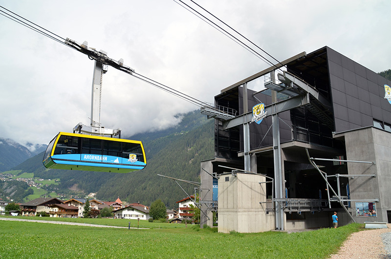
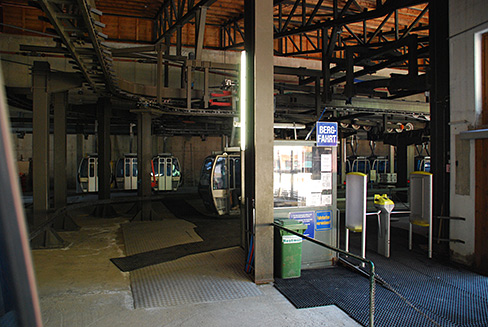
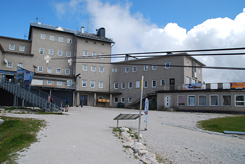
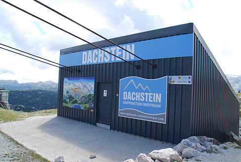
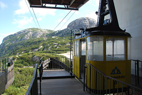
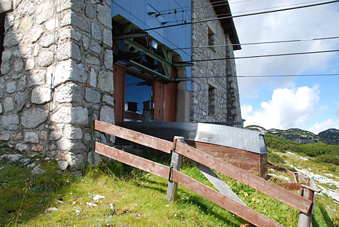
 Giant cabin needs grandiose station house, that really reminding of a huge carton. The valley terminal is made of fair-faced concrete, according to the trend of today's architecture.

ahorn_3.jpg

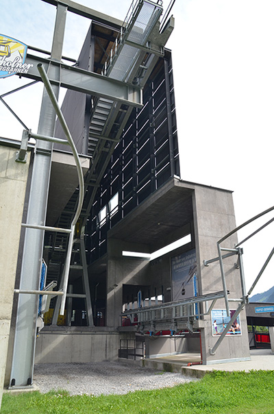
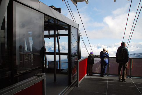
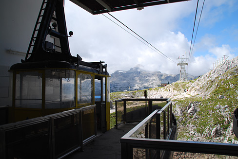
One of the cabin-pair is just at the mountain station, that is why the right side of the terminal is empty. It's interesting that no warning sign or no enclosure is placed around the station at all. Not so noticeable on the photo, but if I came under the arriving cabin (with my 180 cm / 5 ft 11 in height), I would fit. Except the salients of the automatically descending platforms (see a photo sequence of the opening platform by clicking on the link).

Zillertal - Penken:

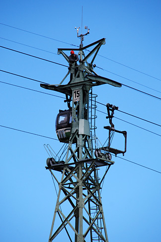
An another ski center of Mayrhofen named Penken can be reached by three different cable cars. One of them built on a steep hillside above the settlement: the gondola-lift of village Finkenberg. This cableway is not so young, it was built in 1987. The four-seated CWA-manufactured cabins look a bit slim nowadays.

finkenberg_2.jpg

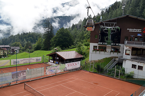
As the village built on a steep area, so have to husband its horizontal areas: for example there is a tennis court directly below the cableway.

penken.jpg

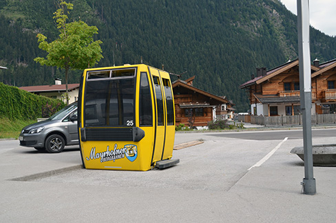
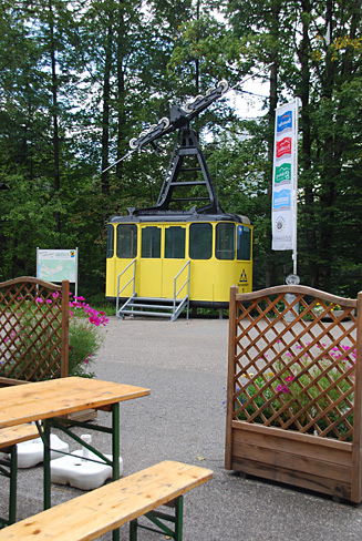
The another lift of Penken starts from Mayrhofen directly. Currently this cableway is completely renovated. As a memento, a cabin of the demolished lift was put down in the parking of Ahornbahn. Who knows how long..

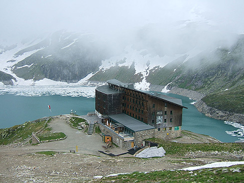
Achensee - Karwendelbahn - Pertisau:

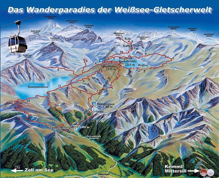
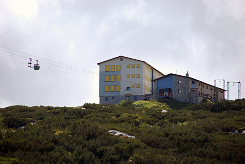
The scenic lake Achensee, located in the north of entrance of Ziller-valley, has two ski-centers. One of them is the Karwendelbahn at Pertisau. The cableway is situated at the edge of the grand Karwendel National Park which is divided between Tyrol and Bavaria.

pertisau_3.jpg

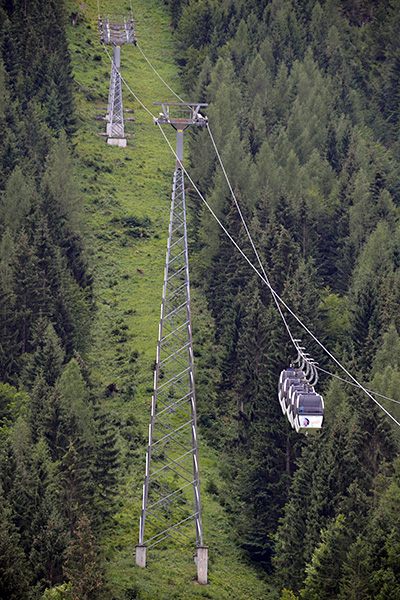
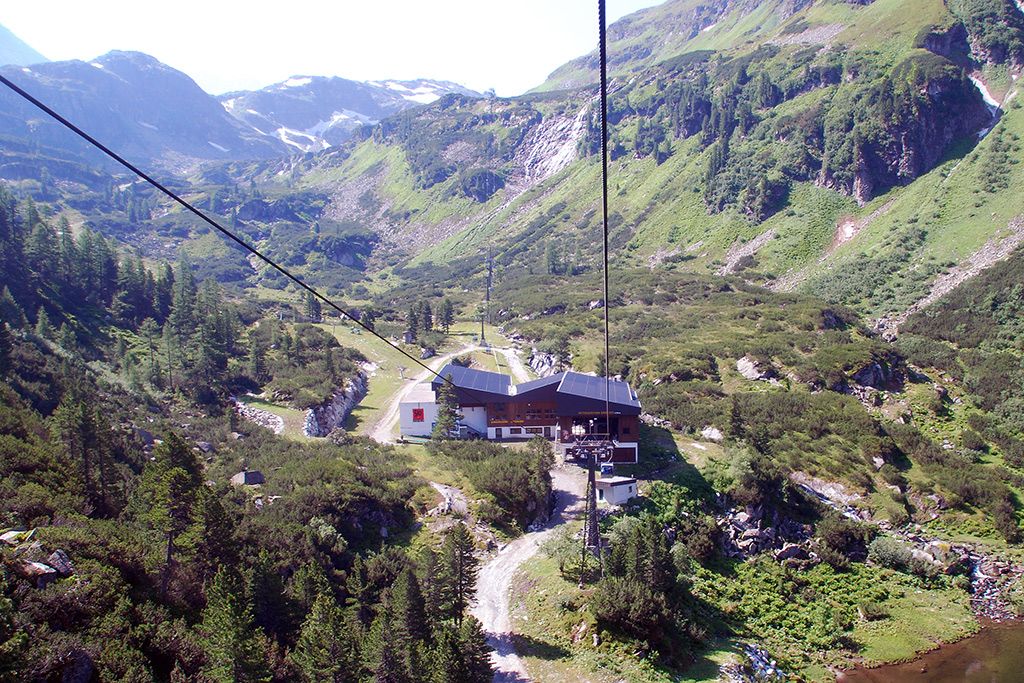
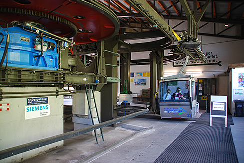
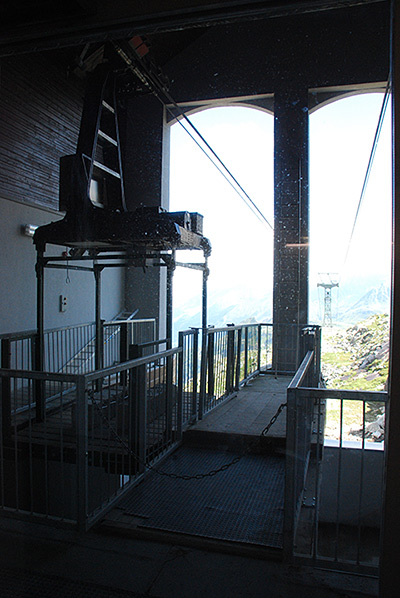
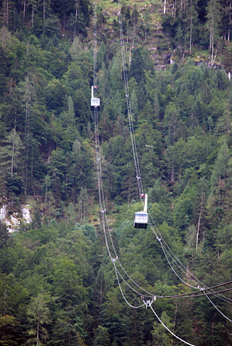
Type of Karwendelbahn is a group-lift, or more precisely: monocable gondola fixed pulsed. Its base structure: one or more pairs (in this case one pair) of cabin groups, involved 3-5 pieces of carrier per group, are fastened on a circulated cable loop. As the cabins which are equipped with fix grip systems arrive to the end station, the whole cable system stops. After loading and unloading, lift is restarted first with carefuly speed, because the group of cabins turns back around the bullwheel before continues the trip back.

22-10-2017 01:25 BundesBlog

Glacierlift at Weißsee - in the heart of High Tauern (2014)


Translated from original entry 28-10-2014


Originally, photos was taken in summer of 2009, however the travelogue written in 2014.

The location is Stubachtal, which a side valley of Saalbachtal in austrian region Pinzgau, near village Uttendorf. At the end of the narrow serpentine road, we can find the valley station of the cable car whereby reach the artificial lake Weißsee, situated 2300 meters (7546 feet) high in picturesque surroundings. That reservoir is the smallest member of Stubachtal Hydroelectric Power Plant: 300 meters (984 feet) below located a much larger lake called Tauernmoosse, which can be reached directly only with special tourist group guiding. Electricity, generated by turbines from the water of Tauernmoossee, is being utilized by the Austrian Federal Railways, the ÖBB. The entire facility is owned by ÖBB-Infrastruktur AG, i.e. the infrastructure division of the railway company. The power station is of the highest importance for Austria, as it supplies 17% of entire electrical network from ÖBB with traction current for locomotives.

Unfortunately, the history of the hydroelectric power plant is not immaculate: although its construction was begun in 1936, however, during the Second World War the building task was accomplished by penal labour for the German Imperial Railroad. Captives were transported from Dachau to the concentration subcamp in Uttendorf, as we can read on a memorial plaque placed near the bank of Weißsee about the tragical events.

weisssee10-s.jpg

Tauernmoossee and the Weißsee reservoir in the National Park Hohe Tauern with the two-sectioned 6-person gondola system, the Weißseebahn I + II (1480 m - 1780 m - 2315 m / 4856 ft - 5840 ft - 7595 ft)
(Source of the map: www.hohetauern.info)

weisssee04-s.jpg

View from Weißseebahn, traveling up towards the middle station which situated in a small valley (by a small lake called Grünsee), so we are going downwards a short stage. Another interesting thing, as seen on the picture, is the two cableway sections which are slightly offset from each other: after arriving at the station building, the cabin slows down and passes an S-shaped supply chain path beside the central garage, continuing the trip to the top end terminal.

weisssee05.jpg

 The middle station inside, at the starting point of the S-shaped path (and guidance rail), due to the offset. There is a possibility to getting off - I also did it, just for a photo shooting. The retrospective feeling of the gondolas is no coincidence: the passenger units were delivered in 1982, and have been being in service since then, but their maintenance is done exemplarily.

weisssee07.jpg

After a left bend, we are going very slowly towards the right bend. Meanwhile, towards the middle of the curve cabin's door is closing (i.e. slamming) and later then is opening again, avoiding to enter the operating area. In the background located the central garage of the lift.

weisssee09.jpg

The reservoir called Weißsee - behind the mountain station, above it the restaurant and hotel Rudolfshütte. A little background info: this is the only one non-self-made photo of this entry, but I think it's pretty important from the aspect of travelouge. I can not explain why did not take a photo from here, especially as I also climbed up onto this high ground.. (Wikipedia - Cactus26 - CC BY-SA 3.0)

weisssee11.jpg

However, I took photograph on the other side: peaks over 3000 metres (9842 ft) with smaller and larger glaciers. Countryside is not accidentally called Weißsee Gletscherwelt (i.e. glacier world). On the left side of the picture is the Johannisberg (3 453 m / 11 329 ft); the highest peak on the right side is the Eiskögele (3 426 m 11 240 ft), which located on the tripoint of austrian federal lands: Salzburg, East-tyrol and Carinthia. If this photo place was even higher, the highest mountain in Austria, the Großglockner (3 798 m / 12 461 ft) could be seen, behind the Eiskögele. Back to the topic of ropeways: in the foreground to the left, a portal supporting tower of a surface lift can be distinctive.

weisssee08.jpg

Next to the terminal of gondola lift, there is the upper end station of the two-section aerial tramway owned by Austrian Federal Railways. Of course I could not enter the plant area, I could only photograph through the glass door this interesting cabin-skeleton, which used to be a passenger cable car, nowadays is functioning as cargo lift. According to newspaper articles, the firm intend to replace it by a complete tunnel system. The line of this cable car is wholly different from the Weißseebahn, except the valley and mountain station points. Its middle station is situated next to the reservoir Tauernmoossee. Moreover, on antique postcards it is shown as the predecessor cable car of present-day ropeway.

weisssee01-s.jpg

 Weßsee with Medelzbahn on the bottom-left side of the photograph: with it the rocky Medelzkopf (2761 m / 9058 ft) can be reached by additional Euros.

weisssee02.jpg

The valley station of Medelzbahn closely.

weisssee03.jpg

.. and even more closely. As seen on the picture, boarding is facilitated by a wooden "podium". There is no need for it in winter, it is substituted with a mass of snow. This type of lift is seen less and less in Austria (it was built in 1980). The voice of its driving-gear is like a "civil defense siren".

17-10-2017 11:56 BundesBlog

Summer travelogue from Dachstein (2014)


Translated from original entry 27-08-2014


About the Dachsteinseilbahn, near to Obertraun and Hallstatt in Salzkammergut, Austria.

Short introduction:

The first and second section of aerial tramway system to the Krippenstein mountain was handed over to the general public in 1951 and 1956, respectively. The base height of valley station not far from the settlement Obertraun is 609 meters, the second terminal is at 2100 meters height. The mountaintop offers a grandiose view to the Hallstatt-Lake and the peaks of Dachstein. At the end of the first section can be found the Dachstein Ice cave (Dachstein-Rieseneishöhle) and the gigantic Dachstein Mammut Cave captivating UNESCO World Heritage. Another lift has been built from the Krippenstein peak, 300 meters down to Gjaidalm in 1961. This became eventually the third section of the aerial tramway system. The first two sections were refurbished in 2007. Above the terminus of Gjaidalm, a military training camp of Austrian Bundesheer at Oberfeld (1835 m) was set up in the 1930s. Ropeways was installed unto this facility at the end of the fifties, which also started from Obertraun. The cable car was only used by military personnel, it was not allowed for tourists. The camp had been used by the Austrian Federal Army until 2009 and it is currently empty. According to Local newspapers it has been bought by private entrepreneur for tourism purposes.

krippenstein-map.jpg

Near the center of the map can be found Krippenstein, on the right side Gjaidalm. Above these areas, peaks of Dachstein are located. Close to the ski slope which is indicated with red line on the graphic, is situated the trace of military cable car. As it did not function as public means of transport, not seen on the ski map at all. (Source of map: www.sielok.hu)

krippenst_15.jpg

At the valley station one of the former cabins has been exhibited. There is a stairway to it and a bench in it, but entering was impossible, because it was closed down. Telling the truth, I had been in it several times when it was in function. In vain, time is running..

krippenst_16.jpg

 The successors: recent cab-pair of the lower section underway. The lift system has double stationary cables, on which roller gears of cabins are running along. The triangular structures which are mounted on these support ropes are responsible for the cables being spaced apart, for example in the case of heavy cross-winds.

krippenst_01.jpg

 Krippenstein, mountain station. After a brief photo shooting we had to leave the platform to give it over the passengers travelling downhill. The cable car system was totally renewed, among others with bigger capacity cabins, but the building has remained the original, that is why the platform, seen on right-bottom side of the picture, slips toward left or right, depending on which cabin arrives.

krippenst_12.jpg

 The same mountain station as on former image. The cables which led from the building are the cable car's stationary supporting ropes..

krippenst_13.jpg

.. are robustly anchored inside this building.

krippenst_03.jpg

The third section, starting from top of Krippenstein, is the only one which has not been refurbished yet. In the background are the peaks of Dachstein mountain.

krippenst_14.jpg

Aeral lift pylon, which was on the former picture as well.

krippenst_04.jpg

Along the way, peeping from the cabin window. This old cable car is characterized by a proper kind of nostalgic atmosphere: the rattling windows, the riveted sliding door closable with tube key, the operator who stares at the landscape underway through the pulled down and drafty window. Technique of the new lifts is naturally fascinating, but these old structures are somehow closer to my soul.

krippenst_17.jpg

And what is he (i.e. the operator) watching throughout the journey? For example the Lake Hallstatt.

krippenst_05.jpg

We have arrived to Gjaidalm. On the opposite side is Krippenstein.

krippenst_07.jpg

 Above Gjaidalm is the abandoned military training camp of Oberfeld. Behind it the rocky Dachstein situated. From the barrack to the right, the smaller building is the mountain station of the military cable car.

krippenst_10.jpg

 The terminal of military cable car, close up. The wooden doors are closed, the place for loading and unloading was inside the building. In the camp building, incidentally, there were one or two workers. One of they opened the window inquiringly. I said eftsoon that I would take only one or two photographs. He closed the window with saying a "passt schon" (that means 'OK' here).

krippenst_11.jpg

 Shortly afterwards, a group-lift appeared on the ropeway, shown above in the picture. One of the mechanics sprang out the cabin, climbed up the supporting pylon and started to cut the uppermost cable with a disc grinder. Certainly, that rope did not participate in the operation of the lift system. During the action, a colleague with a quad-vehicle supervised the area from below, because a falling cable might have cut off something or somebody.

krippenst_18.jpg

They repeated that kind of operation by several supporting pylons before went back to the valley. By the looks of things, preparations of the demolition of the military cable car has begun.

krippenst_09.jpg

A cargo lift was built between the barracks and the Gjaidalm Hütte too. It seems it had been used a great while ago.

süti beállítások módosítása