Quick guide of types Summer travelogues

About CableBlog

English translations from the hungarian ropeway blog site:
kotelpalya.blog.hu


✉ Contact

youtube-logo.png


Coub

Tip

Lift-world.info

Disclaimer

The creation of these blog has not motivated by the profit, but the boundless love of cableways. Authors of this Site have no income from the articles. Picture and video sources in the entries are always displayed.

License of self owned photos:
CC BY-SA

07-11-2017 18:07 BundesBlog

About the forgotten cableway of Aiguille du Midi


Translated from original entry 13-09-2016


People had to wait to conquest Aiguille du Midi (3 842 meters / 12 605 feet) next to Mont Blanc by cableway until 1955, although the first concrete plans had come to light in 1905. Our subject of the following entry is a predecessor lift system, which was more an attempt, because never reached the rough peak of Aiguille du Midi due to many obstacles during the construction.

Of course, the plan seemed brave enough, because the cable transport system was in its infancy at the beginning of the twentieth century. During that period, enthusiastic engineers had been experimenting with a numerous technical solutions to build more efficient and safer cableways. For example the Wetterhorn-Aufzug in 1908, Switzerland's first aerial tramway.

aiguille-du-midi_wiki.jpg

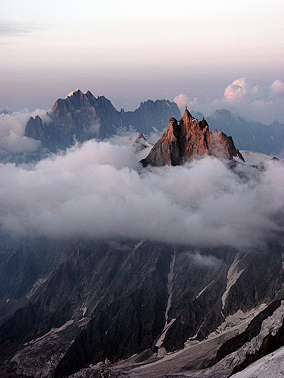
Aiguille du Midi (Wikimedia - Garrondo)

It materializated after the World War I.: the first aerial tram section between 1059 and 1690 meters (3474 and 5545 feet) above sea level was built in 1924, based on the patent plans of the Italian firm named Ceretti & Tanfani. It was led from the valley station at the district of Les Pélerins in Chamonix, to mountain station named La Para. The official handover had been timed for the winter olympic games organized there, because the new lift would have been transported the audience of the bobsleigh event to a temporary mid station. However, it was not succeed to complete till the deadline: only one of the cabin pair operated i.e. without counterbalance, that is why its transport capacity was reduced. The public at large had to wait till summer to try it out excepts personners of the olimpic games.

am_02.jpg

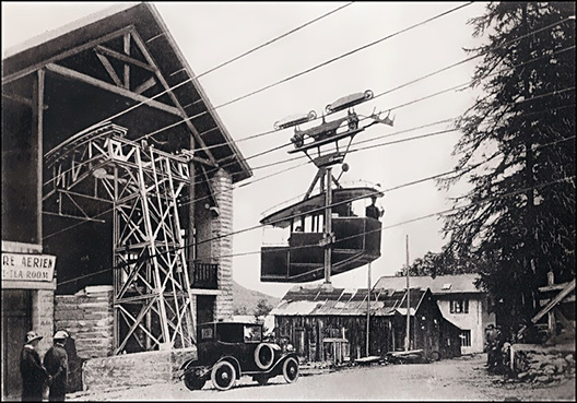
A lift started from Les Pélerins (Chamonix) valley station.
(www.remontees-mecaniques.net - Laurent Berne)

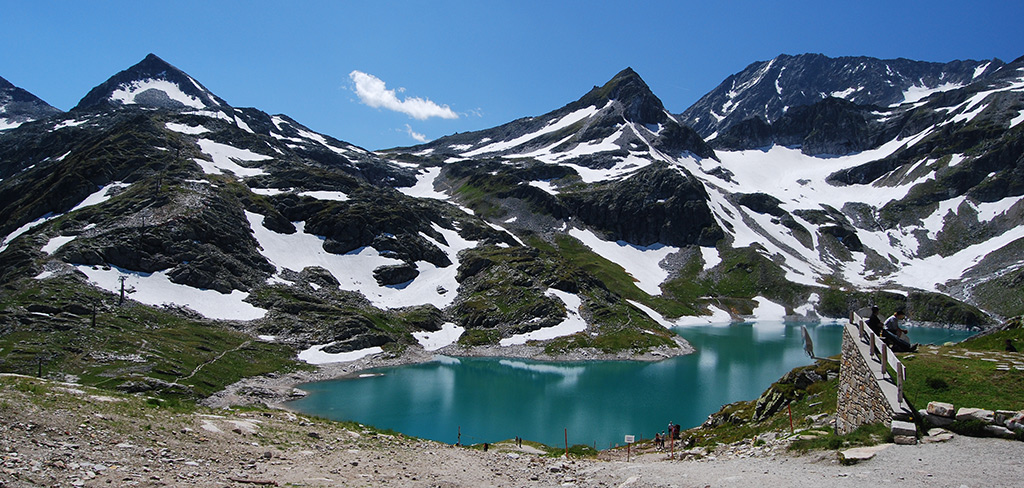
The second section La Para - Les Glaciers (1695 m - 2404 m / 5561 ft - 7887 ft), was presented 3 years after, in 1927. Tourists had been traveled with it on the one hand in the summer period admiring the huge glacier which extended as far as nearly to La Para (i.e. at mid station), but on the other hand in winter time for skiing. Soon the governors of the town and the operators realised the opportunity: ski slopes were marked out, championships were organized, a hotel and a restaurant were built at the top station, ski-rack baskets were mounted on the lift cabins for the convenient travelling.

am_03.jpg

am_11.jpg

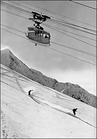
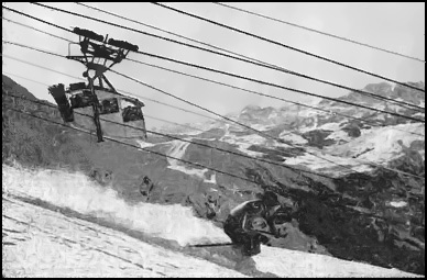
An ancient winter scene of cableways and skiing.
(www.remontees-mecaniques.net - Laurent Berne)

By the plans, the next (i.e third) stage of the whole cableway system was between Les Glaciers and Col du Midi peak (3 600 m / 11 811 ft). From that altitude, both the landscape and the weather become increasingly rough. Engineers planned cabins with big capacity, like at the other lines. That is why, it was introduced a modern system with duplicated stationary support cables, on the one hand to provide lateral stability and stand against cross-winds, on the other hand to support the whole cableway with only one lift pylon - around the middle of the line. The preparatory work was began in 1938 and the building materials and workers were transported by two temporary cargo lifts during the construction: one leaded to the ridge where the central lift pylon had been being built, the other to the peak of Col du Midi. Unlike the "classic" lift-buildings of the existing two sections, a simple concrete structure with a so called sky-touching style was dreamed for the new valley station, according to the "futurist" mood of that epoch. The lift-control buildup - which was installed on the top of the building - was quite unusual too.

am_04.jpg

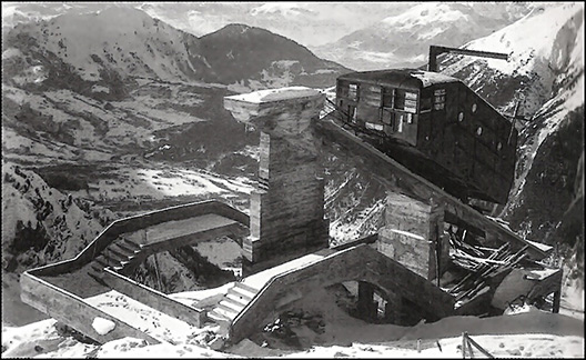
The valley station of the third section. The constructions ended to this phase. The concrete structure was almost ready: it was planned as excessively simple building without any revetment, focusing on functionality. There would have been a driving-gear and a control unit in the carriage-looking engine house which was on the 45-degree ramp. This so called carriage would have rolled back-and-forth on a rail track (fixed on the ramp) by maintaining the dynamic tensions of supporting cables. In addition to tensioning, the construction would have had safety feature: for example the frosted cables due to their extra weight would move the carriage forward, warning the controller to switch to a slower gear. The unusual structure may also be explained by the fact that the 2 kilometers / 1,24 miles long ropeway would have been supported by only one pylon, so that steel ropes would have had larger slack. (www.remontees-mecaniques.net - Monchu)

Despite the outbreak of the World War II., the working did not stop, it was almost always running, but in the last years of the warfare and the following period it slowed down considerably. Building processes stalled by the rough weather conditions, technical fiascos and serious accidents were consuming more and more money. Even the existing ropeways would have required an overall renewal, not only due to their age, but because of their technical obsolescence too. Of course they were renovated towards reliable working: for example getting modern cabins, however their transport capacity proved rather limited. In addition, after the handover tourists still could not have reached the peak of Aiguille du Midi: the fourth (i.e. last) stage had to be built for it. Thanks to these facts, engineers sketched a plan of a brand new, reconsidered and modern two-sectional cable car system, which would shuttle on a wholly new line. Unlike the incomplete predecessor lift, the new ropeway was built within a very short time and it was opened for the general public in 1955. Four years before the official handover in 1951, the old aerial tramways was closed before excursionists and skiers by local authorities for safety reasons. They were allowed only for construction tasks and were permanently shut down in 1958.

ch_map_s.jpg

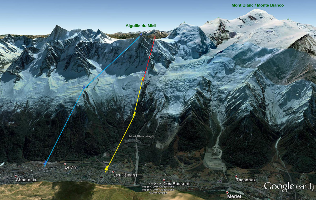
 Location of lthe cable cars. Yellow line: system built in the 1920s (Les Pélerins - La Para - Les Glacier); red line: the unfinished section (Les Glaciers - Col du Midi); blue line: the two-stage lift which still has been operating today (Google Earth)

am_05.jpg

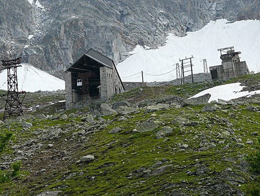
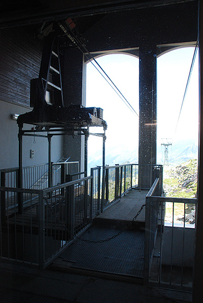
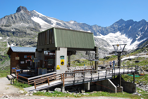
 The mountain station of the second stage at Les Glaciers. The old cableway system has not been dismantled, so buildings, lift pylons and even the cabins can be found as long as they resist the natural forces (or piece of vandalism). To the right of it, the remnants of the unfinished third section seen. (www.camptocamp.org - Christian)

am_08.jpg

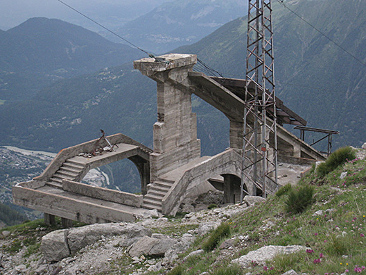
 Abandoned remains of the valley station of the third stage. The abovementioned carriage-looking engine house seems to have lost in the course of time.. (www.camptocamp.org - Maria Goran)

am_07.jpg

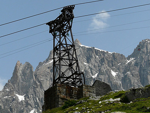
 One of the rusty lift pylons from the line between La Para and Les Glaciers. In the background, on the right side of the picture the successor cable car can be seen during the operation. (www.camptocamp.org - Christian)

am_10.jpg

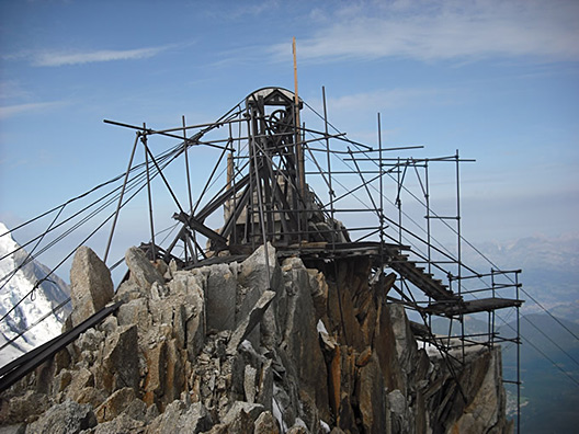
 The top point of the third and unfinished stage at Col du Midi (3 600 m / 11 811 ft) in 2008. It is a miracle that scaffolding has resisted the rough weather such a long time. (www.aiguilledumidi.net)

am_09.jpg

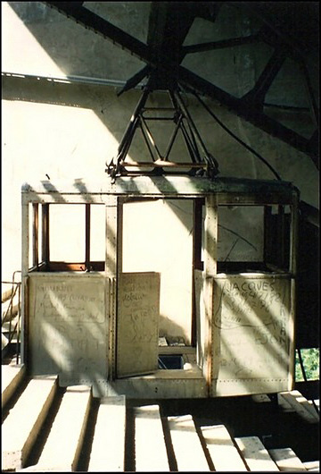
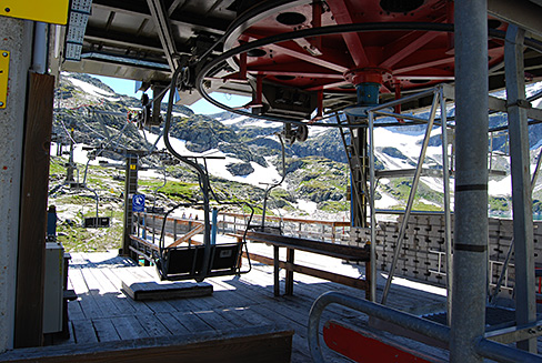
The second generation passenger unit with "decorations" at the mid station named La Para. (www.remontees-mecaniques.net - L. Berne)

am_06-wiki.jpg

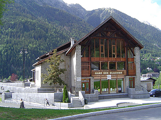
 Valley station of the first stage at Les Pélerins, Chamonix, which is in the best condition. During the 2000s, it was completely renovated, commemorating the pioneers of the cable transport. The front side of the station building (from the direction of the cableway) was closed up with a glass-wall, as seen on the picture. Today its name is Gare des Glaciers and it is operated as accommodation with 5 rooms, a studio and a multi-purpose hall. (Wikimedia - AntonyB)

aiguille-du-midi.jpg

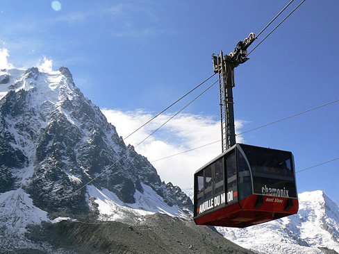
The successor cableway which finally reached the peak of Aiguille du Midi. It was put in operation in 1955 and comprehensively renovated in 1991. (Wikimédia - Clément RAOUX)


Related websites:

29-10-2017 00:49 BundesBlog

Summer travelogue from Tirol (2015)


Translated from original entry 05-08-2015


In the following summer travelogue the eastern region of Tyrol in Austria will be presented.

Zillertal - Ahornbahn:

The cableway from the holiday resort town named Mayrhofen at Ziller-valley leads to the Ahorn ski-center (1965 m / 6447 ft), whereon a pair of 160-person cabins run. The large-scale lifts investment in 2006 resulted in a capacity increase of more than 3 times compared to its predecessor, which was put into operation in 1968. The new cable car was awarded the title of largest aerial tram in Austria.

ahorn_s.jpg

 Giant cabin needs grandiose station house, that really reminding of a huge carton. The valley terminal is made of fair-faced concrete, according to the trend of today's architecture.

ahorn_3.jpg

One of the cabin-pair is just at the mountain station, that is why the right side of the terminal is empty. It's interesting that no warning sign or no enclosure is placed around the station at all. Not so noticeable on the photo, but if I came under the arriving cabin (with my 180 cm / 5 ft 11 in height), I would fit. Except the salients of the automatically descending platforms (see a photo sequence of the opening platform by clicking on the link).

Zillertal - Penken:

An another ski center of Mayrhofen named Penken can be reached by three different cable cars. One of them built on a steep hillside above the settlement: the gondola-lift of village Finkenberg. This cableway is not so young, it was built in 1987. The four-seated CWA-manufactured cabins look a bit slim nowadays.

finkenberg_2.jpg

As the village built on a steep area, so have to husband its horizontal areas: for example there is a tennis court directly below the cableway.

penken.jpg

The another lift of Penken starts from Mayrhofen directly. Currently this cableway is completely renovated. As a memento, a cabin of the demolished lift was put down in the parking of Ahornbahn. Who knows how long..

Achensee - Karwendelbahn - Pertisau:

The scenic lake Achensee, located in the north of entrance of Ziller-valley, has two ski-centers. One of them is the Karwendelbahn at Pertisau. The cableway is situated at the edge of the grand Karwendel National Park which is divided between Tyrol and Bavaria.

pertisau_3.jpg

Type of Karwendelbahn is a group-lift, or more precisely: monocable gondola fixed pulsed. Its base structure: one or more pairs (in this case one pair) of cabin groups, involved 3-5 pieces of carrier per group, are fastened on a circulated cable loop. As the cabins which are equipped with fix grip systems arrive to the end station, the whole cable system stops. After loading and unloading, lift is restarted first with carefuly speed, because the group of cabins turns back around the bullwheel before continues the trip back.

22-10-2017 01:25 BundesBlog

Glacierlift at Weißsee - in the heart of High Tauern (2014)


Translated from original entry 28-10-2014


Originally, photos was taken in summer of 2009, however the travelogue written in 2014.

The location is Stubachtal, which a side valley of Saalbachtal in austrian region Pinzgau, near village Uttendorf. At the end of the narrow serpentine road, we can find the valley station of the cable car whereby reach the artificial lake Weißsee, situated 2300 meters (7546 feet) high in picturesque surroundings. That reservoir is the smallest member of Stubachtal Hydroelectric Power Plant: 300 meters (984 feet) below located a much larger lake called Tauernmoosse, which can be reached directly only with special tourist group guiding. Electricity, generated by turbines from the water of Tauernmoossee, is being utilized by the Austrian Federal Railways, the ÖBB. The entire facility is owned by ÖBB-Infrastruktur AG, i.e. the infrastructure division of the railway company. The power station is of the highest importance for Austria, as it supplies 17% of entire electrical network from ÖBB with traction current for locomotives.

Unfortunately, the history of the hydroelectric power plant is not immaculate: although its construction was begun in 1936, however, during the Second World War the building task was accomplished by penal labour for the German Imperial Railroad. Captives were transported from Dachau to the concentration subcamp in Uttendorf, as we can read on a memorial plaque placed near the bank of Weißsee about the tragical events.

weisssee10-s.jpg

Tauernmoossee and the Weißsee reservoir in the National Park Hohe Tauern with the two-sectioned 6-person gondola system, the Weißseebahn I + II (1480 m - 1780 m - 2315 m / 4856 ft - 5840 ft - 7595 ft)
(Source of the map: www.hohetauern.info)

weisssee04-s.jpg

View from Weißseebahn, traveling up towards the middle station which situated in a small valley (by a small lake called Grünsee), so we are going downwards a short stage. Another interesting thing, as seen on the picture, is the two cableway sections which are slightly offset from each other: after arriving at the station building, the cabin slows down and passes an S-shaped supply chain path beside the central garage, continuing the trip to the top end terminal.

weisssee05.jpg

 The middle station inside, at the starting point of the S-shaped path (and guidance rail), due to the offset. There is a possibility to getting off - I also did it, just for a photo shooting. The retrospective feeling of the gondolas is no coincidence: the passenger units were delivered in 1982, and have been being in service since then, but their maintenance is done exemplarily.

weisssee07.jpg

After a left bend, we are going very slowly towards the right bend. Meanwhile, towards the middle of the curve cabin's door is closing (i.e. slamming) and later then is opening again, avoiding to enter the operating area. In the background located the central garage of the lift.

weisssee09.jpg

The reservoir called Weißsee - behind the mountain station, above it the restaurant and hotel Rudolfshütte. A little background info: this is the only one non-self-made photo of this entry, but I think it's pretty important from the aspect of travelouge. I can not explain why did not take a photo from here, especially as I also climbed up onto this high ground.. (Wikipedia - Cactus26 - CC BY-SA 3.0)

weisssee11.jpg

However, I took photograph on the other side: peaks over 3000 metres (9842 ft) with smaller and larger glaciers. Countryside is not accidentally called Weißsee Gletscherwelt (i.e. glacier world). On the left side of the picture is the Johannisberg (3 453 m / 11 329 ft); the highest peak on the right side is the Eiskögele (3 426 m 11 240 ft), which located on the tripoint of austrian federal lands: Salzburg, East-tyrol and Carinthia. If this photo place was even higher, the highest mountain in Austria, the Großglockner (3 798 m / 12 461 ft) could be seen, behind the Eiskögele. Back to the topic of ropeways: in the foreground to the left, a portal supporting tower of a surface lift can be distinctive.

weisssee08.jpg

Next to the terminal of gondola lift, there is the upper end station of the two-section aerial tramway owned by Austrian Federal Railways. Of course I could not enter the plant area, I could only photograph through the glass door this interesting cabin-skeleton, which used to be a passenger cable car, nowadays is functioning as cargo lift. According to newspaper articles, the firm intend to replace it by a complete tunnel system. The line of this cable car is wholly different from the Weißseebahn, except the valley and mountain station points. Its middle station is situated next to the reservoir Tauernmoossee. Moreover, on antique postcards it is shown as the predecessor cable car of present-day ropeway.

weisssee01-s.jpg

 Weßsee with Medelzbahn on the bottom-left side of the photograph: with it the rocky Medelzkopf (2761 m / 9058 ft) can be reached by additional Euros.

weisssee02.jpg

The valley station of Medelzbahn closely.

weisssee03.jpg

.. and even more closely. As seen on the picture, boarding is facilitated by a wooden "podium". There is no need for it in winter, it is substituted with a mass of snow. This type of lift is seen less and less in Austria (it was built in 1980). The voice of its driving-gear is like a "civil defense siren".

süti beállítások módosítása